The History and Life of the Warwickshire Village
of Lillington
Lillington, once an independent rural settlement and now a suburb of Leamington Spa, boasts a
rich history spanning over a millennium. Originally a Saxon settlement that evolved through
medieval abbey ownership to become a thriving agricultural community, Lillington’s character
has been shaped by changing land ownership, industrial development, and eventually suburban
expansion. This report traces its evolution from early origins documented in the Domesday Book
through its agricultural heyday, Victorian expansion, and eventual integration with Leamington
Spa, revealing how this ancient settlement has maintained elements of its village identity despite
significant urban development.
Geographic Setting and Early Origins
Lillington sits northeast of Leamington Spa in Warwickshire, England. While now firmly part of the
Royal Leamington Spa civil parish maintains a distinct identity as a historical settlement
and modern residential district. The area features the Campion Hills, which rise to 97m 318 ft
above sea level and offer panoramic views across Leamington Spa.
This elevated terrain has
made Lillington a prominent geographic feature in the landscape, with Eden Court, its fifteen-story tower block, visible for miles around.
Archaeological evidence confirms human activity in the area long before written records began.
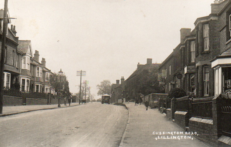
Stone Age remains and prehistoric elephant and woolly rhinoceros fossils were discovered in the
The Cubbington Road area attests to the area’s ancient past. Roman artefacts and burials have also
been uncovered in the vicinity of Highland Road and Braemar Road, indicating continued
settlement through different historical periods.
By the time of the Norman Conquest, Lillington was already an established settlement.The
Domesday Book of 1086 records it as having approximately 16 households, suggesting a
population of about 50 people. Following the Norman Conquest, William I granted the land
to the Count of Meulan as a reward for his service at the Battle of Hastings. This marked the
beginning of the documented history of Lillington’s changing ownership and development.
Medieval Period and Religious Influence
The medieval period brought significant changes to Lillington’s ownership and character. In 1121,
the manor of Lillington was given to Kenilworth Abbey, beginning over four centuries of monastic
influence. This ecclesiastical connection profoundly shaped the village’s development and
religious life.
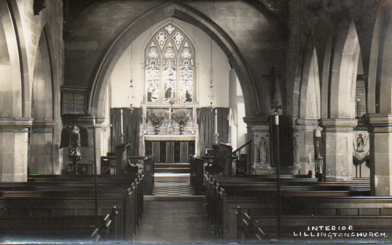
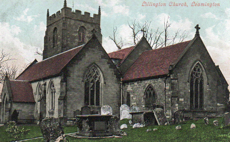
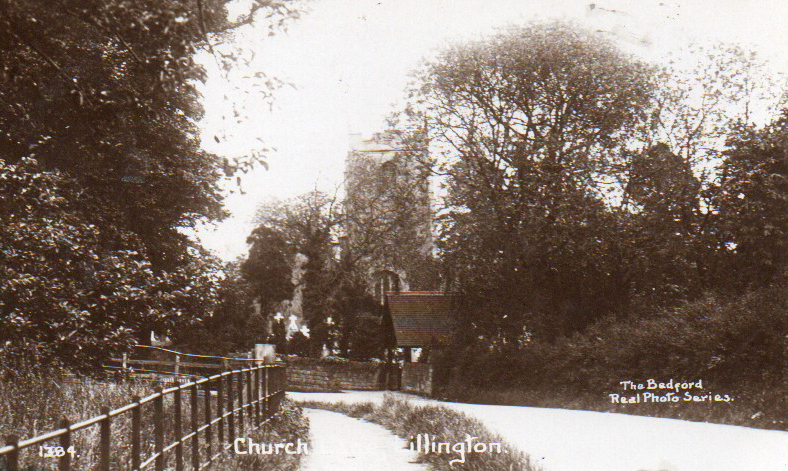
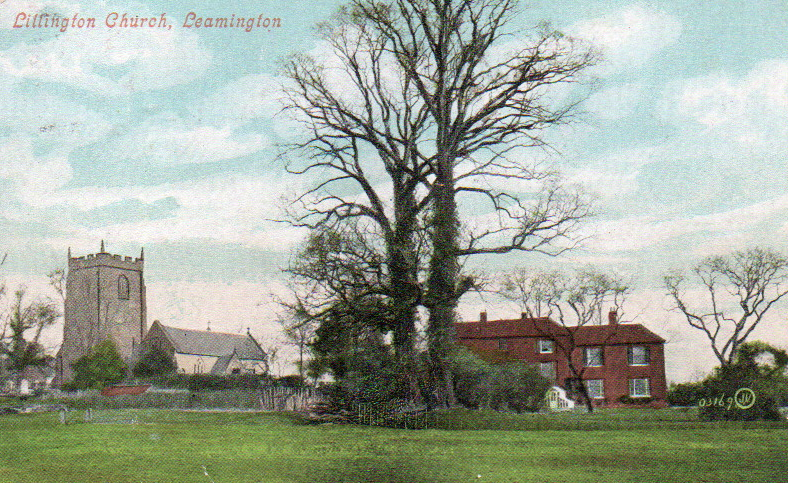
Evidence of Lillington’s pre-Norman religious significance survives in its parish church. St. Mary
Magdalene Church contains Saxon elements, including part of the south wall of the present
chancel and a Saxon doorway dating from approximately 1020, which was reportedly repaired
after Canute’s 1016 raid into Warwickshire. This doorway represents a thousand-year-old
architectural connection to Lillington’s earliest Christian community.
By around 1380, the chapel had developed into a proper parish church with chancel, nave, and
a short south aisle of two bays. Further architectural development continued with the addition
of the west tower around 1480, which still houses a contemporary bell cast around this time and
dedicated to St. Catherine. The bell hangs in the tower today, connecting to Lillington’s medieval past.
The religious landscape of Lillington underwent dramatic change during the Reformation. When
Henry VIII dissolved the monasteries in 1538; Lillington’s long relationship with Kenilworth Abbey
ended. The village’s lands returned to secular ownership, marking a significant
transition in the community’s history.
Post-Reformation Ownership and Development
Following the dissolution of Kenilworth Abbey, Queen Elizabeth I granted the manor of Lillington
to Sir John Puckering of Warwick in 1596.
The Puckering family maintained ownership until
1709, when they sold the estate to Henry Wise, marking the beginning of the Wise family’s
significant influence on Lillington’s development.
Understanding property boundaries became increasingly crucial as land changed hands. In
1711, Henry Wise commissioned James Fish to create “an exact map” of Lillington. This map,
an essential historical document, revealed the medieval three-field system still in operation, with the
land divided into strips to ensure each tenant farmer had an equal share of the good and the poor
land.
The map also documented the pattern of roads, many of which remain recognisable
Today, despite name changes, it showed the cottages and principal farms clustered near the
church and Manor House.
Fish was commissioned to resolve disputes between Lord Brooke and Henry Wise regarding land
ownership, as these disagreements had become “very inconvenient, …and have often occasioned
disputes in ploughing, in mowing their grass, and is a discouragement to husbandry”. These
Disputes were finally settled in 1730 under the Enclosure Act, when the great fields were divided
and assigned to specific farms and landowners
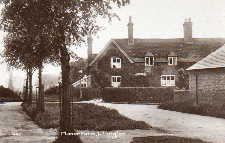
The fields were reorganised and allocated
to the three main farms: Manor Farm (in Lime Avenue), Village Farm (where Tesco’s now stands),
and Grange Farm on Cubbington Road near Pound Lane.
Through the 18th and 19th centuries, the Wise family maintained significant influence in
Lillington. By 1870, H. Wise, Esq., owned the manor and most of the land. The Wise family’s
Connection to Lillington eventually gave way to the Waller family, who sold the last of their
Lillington landholdings in the 1920s.
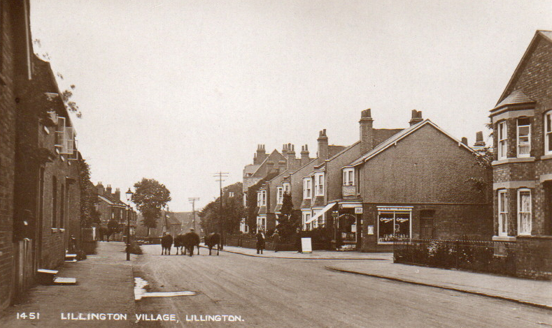
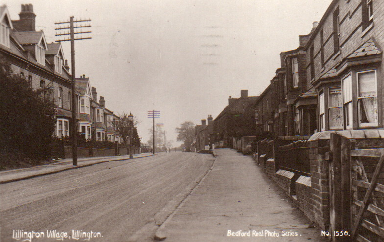
Victorian Expansion and Industrial Development
The 19th century brought substantial change to Lillington, mainly due to the growth of
neighbouring Leamington Spa as a fashionable spa town. By 1870, Lillington parish covered 1,324
acres with real property valued at £6,460. The population grew from 309 in 1851 to 480 in
In 1861, an increase was attributed to expanded housing accommodations.
This period established several prominent residences, including Lillington House, Blackdown House,
and Elm Bank.
The popularity of Leamington’s spa waters directly impacted Lillington’s development.
Wealthy families built substantial houses along Lillington Avenue, creating employment
opportunities for local people as gardeners and servants. By the end of the 19th century,
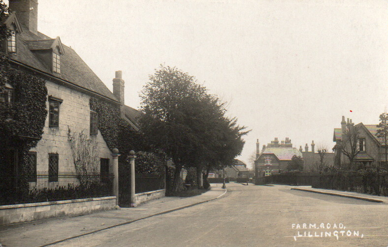
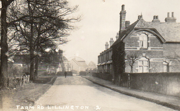
increased housing demand led to constructing of terraced houses in Lime Avenue, Manor
and Farm Roads, and along Cubbington Road.
Industrially, Lillington developed several significant enterprises. Brick production became an
important local industry, with evidence of brickmaking dating back to at least 1808.
The 1886 Ordnance Survey map shows several kilns, a chimney, and a light railway on land now covered
by Waller Street, Campion Road, Greville Street, and Villiers Street. The brickworks, owned by
the Wise family and leased to contractors, utilised the area’s clay deposits, with an 1884 lease
permitting clay extraction to a depth of three feet for “bricks, quarry tiles and pipes”.
Other industries included a brewery on Lillington Avenue (now converted to residential use as
“The Maltings”) and several sand and gravel extraction pits near the centre of Lillington.
These industries, along with agriculture, employed the growing population.
Education and Community Development
As Lillington’s population grew, so did the need for educational facilities. In early Victorian
In England, the Reverend John Wise recognised the need for formal education in the village.
The first school building was constructed with a school room on the ground floor and the
schoolmistress’s accommodation on the upper floor. By 1864, the building was extended to
serve multiple purposes: a school during the day and “a reading room for the labouring men of
the village” at other times. This facility became Lillington’s first library, demonstrating the
village’s commitment to education and community development.
The school became increasingly popular, with classes sometimes numbering up to 60 pupils of
different ages and abilities under the instruction of monitors (older children) and pupil teachers
working under the schoolmistress’s direction. Education became free in 1890/91,
marking a significant step in the community’s educational development.
The village’s community infrastructure continued to develop throughout the late 19th and early
20th century. The Imperial Gazetteer of 1870 notes a national school and a
working-men’s reading room.
The parish church of St. Mary Magdalene underwent significant
restoration and enlargement between 1847 and 1884 to accommodate the growing
population.
The McGregor Era and Horse Breeding
The early 20th century saw the rise of another influential family in Lillington’s development,
McGregor’s. Edward McGregor and his sons, Sydney McGregor and Edward Jr., played
instrumental roles in developing the eastern and southern parts of the village from around 1928
through the 1970s.
Sydney McGregor 18891970) established Lillington as a centre for horse breeding through his
stud farm. His most famous horse was April the Fifth, which won the Epsom Derby in
1932. April the Fifth was a British Thoroughbred racehorse bred by McGregor in partnership
with Mr. G.S.L. Whitelaw at the Lillington Stud near Leamington Spa. The horse was foaled on
April 5, which was also McGregor’s birthday.
After Sydney McGregor died in 1970, the stud farm area was developed for housing, with
many new roads being given racing-related names, such as Epsom Road. This development
represented a significant transition from agricultural to residential use, reflecting broader
changes in Lillington’s character.
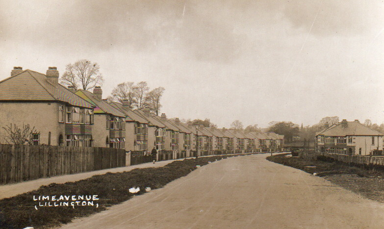
Twentieth Century Expansion and Integration with Leamington Spa
Lillington’s transformation accelerated in the 20th century. In 1890, the village was incorporated
into the borough of Leamington, marking the end of its administrative independence. By 1901,
The parish had a population of 1,241. On April 1, 1902, the parish was officially abolished to
form “Leamington”.
Buildings continued after World War I, with the Holt development being constructed to rehouse families
relocated from Leamington’s worst slums. The most extensive building program followed
World War II, when the McGregor brothers sold their land for extensive building north and south
of Cubbington Road. The street names reflect their interests: Scottish names from Lime Avenue to
Telford Avenue and racecourse names honour the area’s history as a stud farm.
The new centre of Lillington formed around Crown Way, which opened in the early 1950s. This the
area was predominantly built as a council house estate and includes three tower blocks, with the
Fifteen-story Eden Court is the most prominent. The last of the original cottages in
Cubbington Road was demolished in the 1970s, symbolising the completion of Lillington’s
transformation from village to suburb.
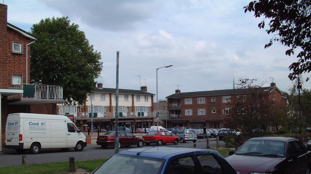
Modern Lillington retains two distinct areas: the newer Crown Way centre with its shops and
amenities, and the older area containing the former village core with the parish church, manor
house, Victorian terraced houses, and post-1930 housing estates. The community continues
to evolve, with former facilities repurposed: the police station became a dentist’s office, the
Walnut Tree public house became a Tesco supermarket, and the original library became a
nursery school.
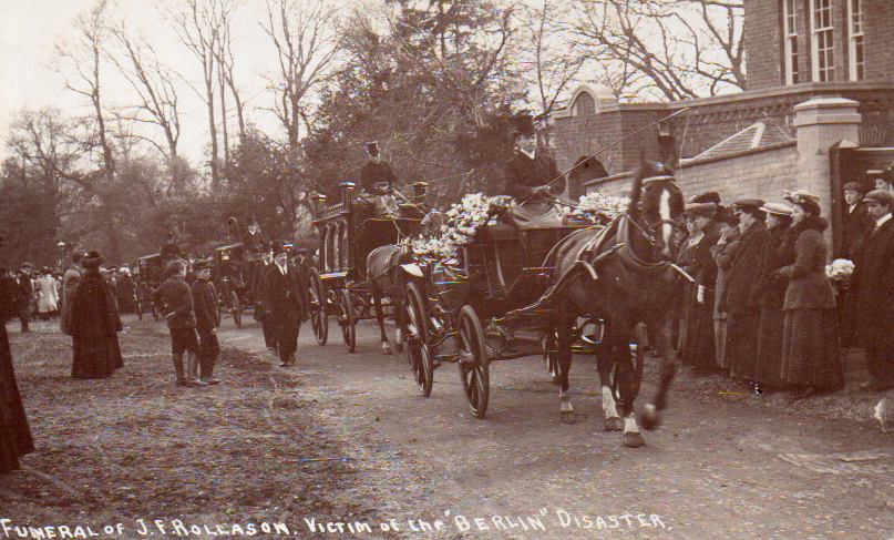
The Mystery of J.F. Rollason: Exploring a Lillington Jockey’s Death in 1907
Historical Background and Identity
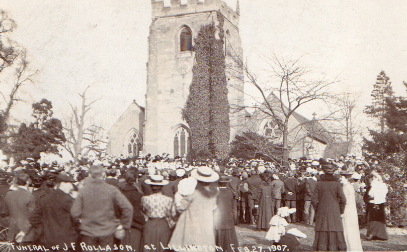
Lillington jockey named JF Rollason who died in a According to historical records, a man named John Francis Rollason (1887-1907), described as a “well-known Leamington jockey,” was buried in Lillington following his death at age 20.
Historical documentation indicates that Mr. Rollason’s funeral occurred on February 27th, 1907, at St Mary’s Church in Lillington. Records note a “large gathering of people” in attendance. This suggests he was of some local significance, aligning with his description as a “well-known” jockey.
Cause of Death: Maritime Incident
The information I have found indicates that Mr John Francis Rollason drowned in the sinking of the ship “Berlin” off the Hook of Holland with his father, Edward Rollason, on their way back from a racing engagement in Holland on February 27th 1907.
The timing of his death and funeral in early 1907 places this tragedy in the Edwardian era, a
period when maritime travel remained the primary means of international transportation.
The Leamington Brick Company:
Its Association
With Lillington and Industrial Infrastructure
The Leamington and Lillington brick works represent a fascinating chapter in local industrial
history, operating from the nineteenth century until the mid-twentieth century. This report
examines the connection between the brickworks and Lillington village, the clay and material
extraction sites, and the light railway system that served the industrial operation.
Historical Development and Ownership
The Leamington and Lillington brick works operated from the nineteenth century until the 1950s,
situated off Campion Road in Leamington Spa. Evidence suggests that brick production in the
area dates back to at least 1808, with correspondence between Edward Willes (the original
owner) and his agent referencing small brick kilns on various construction sites. By the late
nineteenth century, the operation had expanded significantly.
The brickworks were initially owned by Edward Willes of Newbold Comyn and covered an
extensive area between Midland Oak Park, Leicester Street, and Lillington Road. The Wise
family later acquired ownership and leased the works to various contractors. An 1884 lease
between George Wise and Mann & Mills specified that clay could be extracted to a depth of
three feet for manufacturing “bricks, quarry tiles and pipes,” with the requirement that topsoil be
replaced afterwards for cultivation.
Ownership changed again when the operation was briefly held by the Leamington & Lillington
The Brickyard Company was purchased in 1891 by Henry Hawkes. By its
closure around 1960, the bricks were fired in a large Hoffmann kiln.
Geographic Extent and Local Significance
The Leamington and Lillington Brickworks were firmly established in the local landscape,
appearing on the Ordnance Survey map of 1886. They were located in what is now the area
of Hazel Close in Leamington Spa, with operations spanning lands that are currently occupied
by the eastern parts of Waller Street, Campion Road, Greville Street, and Villiers Street.
The brick yards in Leicester Street were notably part of the manor of Lillington, establishing a
clear administrative connection between the industrial operation and the village. The 1886
The Ordnance Survey map shows several kilns, a chimney, and, importantly, a light railway system
operating within this area.
The products of the brickworks became integral to local architecture, with their bricks found in
almost all Victorian and Edwardian buildings throughout both Leamington and Lillington. The
operation continued to support the local building industry until its closure around 1960.
Clay Extraction and Material Pits
The Cliffs and Material Extraction
A significant feature of the brickworks operation was an area known as “The Cliffs,” which ran
across the back of the site where Kiln Close is now located. This was characterised by an almost
sheer face of heavy clay with steps (locally called the “Monkey Steps”) cut into the face,
leading to old allotments behind Gresham Avenue.
Beyond its industrial function, this area served a social purpose for the community, becoming a
regular playground for local children on weekends when machinery was inactive. It also provided
a convenient pedestrian route from Campion Hills and Lillington Prefabs down to town.
Sand and Gravel Extraction.
In addition to clay extraction, several pits are slightly north of where Elm Bank Close backs onto
Lillington Close were used for sand and gravel extraction. These materials were in high demand
during the nineteenth-century building booms in Leamington. The local geology proved ideal
for obtaining various building materials, making the area a natural choice for this industry.
The Light Railway System
Transport Infrastructure
One of the most intriguing aspects of the brickworks was its transport system. Evidence
confirms the existence of a small tramway system within the Leamington brickworks. Physical
remains of a railway track have been documented at the end of gardens where Elm Bank Close
backs onto Lillington Close.
The 1886 Ordnance Survey map of Leamington explicitly shows a light railway on land now
covered by residential streets, providing contemporary evidence of this industrial
infrastructure. This light railway would have been typical of industrial operations of the period,
with tracks that could be easily lifted and relocated as needed.
Operation and Evolution
In the 1930s, this small railway was explicitly used to transport clay from the extraction pits to
processing areas where it was crushed into powder. The transportation system evolved, with the railway eventually replaced by a dumper truck by the 1950s as
mechanisation advanced.
The operation of the railway likely varied over its lifetime. Historical evidence suggests that in
similar light railway systems, wagons were either moved by horses or pushed manually by
workers, who would take advantage of natural gradients when possible.
I know that steam engines worked this particular railway that ran between Leamington Brickworks and Lillington Village, I know this because in 1958 I found a full-size Steam engine in a small coppice of trees at the bottom of Lillington Close. Like most boys, I was into trains at that particular time. This steam engine was about 11 feet long. It had three steps up to the cab, which was quite big, enough to get three eleven-year-old boys to jump around and have a great time. Later that year it disappeared I think it was sold for scrap but don’t know any more about it.
There were quite a few Railway lines in the coppice. The steam engine stood on some of these. I recognised these lines because they were the same size as some that had been running down Valley Road when we moved to Lillington in 1952. They came from the direction of the Council rubbish tip, where the Catholic Church in Valley Road now stands. By 1954, the lines had disappeared, and the new playing field for Lillington Junior School was being built.
I used to get beautiful watercress out of the Bins Brook, which ran parallel to the railway line and where Valley Road is now.
Religious Life and Community Identity
Despite changes, religious institutions have remained central to Lillington’s community identity.
St. Mary Magdalene Church continues as the parish church, preserving its ancient heritage while
serving the contemporary community. The Roman Catholic Church of Our Lady in the Valley
Road, consecrated in 1963, features notable stained glass in the ‘Dalle de verre’ style designed
by Dom Charles Norris of Buckfast Abbey. Lillington Free Church on Cubbington Road
represents another significant religious community.
Community identity is also preserved through organisations like the Lillington Local History
Society was founded in 2009 to promote the study of local history and foster a sense of belonging
among residents. The society organises discussions, talks, and visits, encouraging research
into local stories and maintaining connections with neighbouring communities.

Modern Lillington
Today, Lillington serves as a suburban ward of both the Warwick District Council and the Royal
Leamington Spa Town Council. Recent census data shows a relatively stable population:
12,031 in 2001, 11,930 in 2011, and 11,908 in 2021. The area maintains educational facilities,
including Lillington Nursery and Primary School, Telford Infant and Junior Schools, with North
Leamington School serves as the nearest secondary school. A Sure Start Children’s Centre
opened in 2006, adjacent to the community centre and Lillington Library on Mason Avenue.
Notable landmarks include the Midland Oak at the junction of Lillington Avenue and Lillington Road, which marks the supposed centre of England.
The original oak, thought to have dated
from the 16th century, died and was removed in 1967. Its successor was planted in the 1980s
from an acorn collected from the original tree.
The Campion Hills continue to serve practical and recreational purposes, hosting Leamington’s
transmission tower, the Severn Trent water treatment plant, and a BMX track run by Warwick
District Council. These hills offer panoramic views over Leamington Spa and beyond,
connecting modern residents with the landscape that has shaped Lillington’s development for
centuries.